

| |
Mizoram is a state in the far northeast of India. It is the southernmost of the hill states, and lies between Burma in the east and Bangladesh in the west.
Climate: Mizoram lies in the monsoon belt between South and Southeast Asia. The hills are high enough to give cooler summers than on the plains of Bangladesh or Burma. Even so, in summer, average maximum temperatures are 29 �C and average minimum temperatures are 20 �C.
History. Mizoram has long been an area of tribal movement. The different groups of tribal people originally came from northwest China, and gradually moved southward toward Tibet and Burma in the A.D. 600's. They reached Mizoram in the 1700's. In 1898, it was formed into the Lushai Hills District and became part of Assam. Under colonial rule, Christian missionaries entered the area freely. They not only carried out their religious duties by converting the tribals into Christanity (often forcibly) but also introduced literacy, which is exceptionally high in this state. The written language uses the Roman script. The Indian parliament renamed the territory the Mizo Hills District in 1954. The territory was called Mizoram when it became a union territory on Jan. 21, 1972. It became a state on Feb. 20, 1987. |
Copyright ©2000 indiansaga.info. All rights reserved.
By using this service, you accept that you won't copy or use the data given in this website for any commercial purpose.
The material on indiansaga.info is for informational & educational purpose only.
This site is best viewed at 800 X 600 picture resolution.


 Mizoram has a long eastern border with Burma.
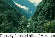
  Tourist Centres: Known as the land of the enchanting hills, Mizoram is famous for its vast expanse of jagged mountain ranges shrouded mystically in reddish blue haze. Blue mountains and deep narrow valleys with swift flowing rivers, forest with an array of flora and fauna, quaint relics of a glorious past, quite hamlets and bustling towns make Mizoram a perfect tourist's choice.